Weather Alert in South Carolina
Flash Flood Warning issued September 7 at 4:59PM EDT until September 7 at 7:15PM EDT by NWS Charleston SC
AREAS AFFECTED: Charleston, SC
DESCRIPTION: At 459 PM EDT, Doppler radar indicated showers and thunderstorms with heavy rain over much of West Ashley, Johns Island James Island. As much as 2 to 4 inches of rain have fallen across this area this afternoon. While activity will slowly weaken, an additional 1 to 2 inches could fall through 715 PM. The risk for flash flooding continues. In addition, water levels in Church Creek in West Ashley are steadily rising. People living along the creek should carefully monitor water levels over the next few hours as there is a chance the creek should exceed the minor flood stage of 5.5 feet. HAZARD...Flash flooding caused by thunderstorms. SOURCE...Radar indicated. IMPACT...Flash flooding of small creeks and streams, urban areas, highways, streets and underpasses as well as other poor drainage and low-lying areas. Some locations that will experience flash flooding include... North Charleston, Hanahan, West Ashley, I-26/I-526 Interchange, Johns Island, James Island, Hollywood, Ravenel and Meggett. This includes the following highways... I-26 between mile markers 210 and 220. I-526 between mile markers 11 and 22.
INSTRUCTION: Turn around, don't drown when encountering flooded roads. Most flood deaths occur in vehicles. Report flooding directly to the Charleston National Weather Service at 1-888-383-2024 or email your reports to nws.charlestonsc@noaa.gov.
Want more detail? Get the Complete 7 Day and Night Detailed Forecast!
Current U.S. National Radar--Current
The Current National Weather Radar is shown below with a UTC Time (subtract 5 hours from UTC to get Eastern Time).

National Weather Forecast--Current
The Current National Weather Forecast and National Weather Map are shown below.

National Weather Forecast for Tomorrow
Tomorrow National Weather Forecast and Tomorrow National Weather Map are show below.

North America Water Vapor (Moisture)
This map shows recent moisture content over North America. Bright and colored areas show high moisture (ie, clouds); brown indicates very little moisture present; black indicates no moisture.

Weather Topic: What is Freezing Rain?
Home - Education - Precipitation - Freezing Rain
 Next Topic: Graupel
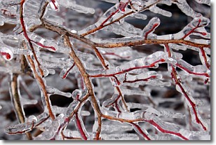
Freezing rain is a condition where precipitation which has fallen in the form of
water droplets reaches temperatures which are below freezing and freezes upon
coming into contact
with surface objects. The result of this precipitation is a glaze of ice which
can be damaging to plants and man-made structures. A severe onset of freezing
rain which results in a very thick glaze of ice is known as an ice storm.
Next Topic: Graupel
Weather Topic: What is Hail?
Home - Education - Precipitation - Hail
 Next Topic: Hole Punch Clouds
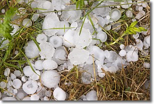
Hail is a form of precipitation which is recognized by large solid balls or
clumps of ice. Hail is created by thunderstorm clouds with strong updrafts of wind.
As the hailstones remain in the updraft, ice is deposited onto them until their
weight becomes heavy enough for them to fall to the earth's surface.
Hail storms can cause significant damage to crops, aircrafts, and man-made structures,
despite the fact that the duration is usually less than ten minutes.
Next Topic: Hole Punch Clouds
Current conditions powered by WeatherAPI.com


