Weather Alert in Wisconsin
Special Weather Statement issued August 22 at 2:37PM CDT by NWS Green Bay WI
AREAS AFFECTED: Vilas; Oneida
DESCRIPTION: At 236 PM CDT, Doppler radar was tracking strong thunderstorms along a line extending from 9 miles southeast of Gile to 6 miles west of Turtle Flambeau Flowage to 12 miles northwest of Phillips. Movement was east at 30 mph. HAZARD...Wind gusts up to 40 mph and pea size hail. SOURCE...Radar indicated. IMPACT...Gusty winds could knock down tree limbs and blow around unsecured objects. Minor hail damage to vegetation is possible. Strong thunderstorms will be near... Winchester around 255 PM CDT. Lac Du Flambeau and Rice Creek Natural Area around 315 PM CDT. Border Lakes Natural Area around 320 PM CDT. Other locations impacted by these storms include Sayner, Nixon Lake Natural Area, Hazelhurst, Woodruff, Tomahawk River Pines Natural Area, High Lake Natural Area, Arbor Vitae, Van Vliet Hemlocks Natural Area, Trout Lake, and Manitowish Waters.
INSTRUCTION: If outdoors, consider seeking shelter inside a building.
Want more detail? Get the Complete 7 Day and Night Detailed Forecast!
Current U.S. National Radar--Current
The Current National Weather Radar is shown below with a UTC Time (subtract 5 hours from UTC to get Eastern Time).

National Weather Forecast--Current
The Current National Weather Forecast and National Weather Map are shown below.

National Weather Forecast for Tomorrow
Tomorrow National Weather Forecast and Tomorrow National Weather Map are show below.

North America Water Vapor (Moisture)
This map shows recent moisture content over North America. Bright and colored areas show high moisture (ie, clouds); brown indicates very little moisture present; black indicates no moisture.

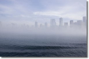
Weather Topic: What is Fog?
Home - Education - Cloud Types - Fog
 Next Topic: Fractus Clouds
Fog is technically a type of stratus cloud, which lies along the
ground and obscures visibility.
It is usually created when humidity in the air condenses into tiny water droplets.
Because of this, some places are more prone to foggy weather, such as regions
close to a body of water.
Fog is similar to mist; both are the appearance of water droplets suspended in
the air, but fog is the term applied to the condition when visibility is less than 1 km.
Next Topic: Fractus Clouds
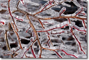
Weather Topic: What is Freezing Rain?
Home - Education - Precipitation - Freezing Rain
 Next Topic: Graupel
Freezing rain is a condition where precipitation which has fallen in the form of
water droplets reaches temperatures which are below freezing and freezes upon
coming into contact
with surface objects. The result of this precipitation is a glaze of ice which
can be damaging to plants and man-made structures. A severe onset of freezing
rain which results in a very thick glaze of ice is known as an ice storm.
Next Topic: Graupel
Current conditions powered by WeatherAPI.com


