Weather Alert in Pennsylvania
Severe Thunderstorm Warning issued September 4 at 7:03PM EDT until September 4 at 7:30PM EDT by NWS State College PA
AREAS AFFECTED: Columbia, PA
DESCRIPTION: SVRCTP The National Weather Service in State College PA has issued a * Severe Thunderstorm Warning for... East central Columbia County in central Pennsylvania... * Until 730 PM EDT. * At 702 PM EDT, a severe thunderstorm was located over Mifflinville, moving northeast at 40 mph. HAZARD...60 mph wind gusts. SOURCE...Radar indicated. IMPACT...Expect damage to roofs, siding, and trees. * Locations impacted include... Bloomsburg, Berwick, Mifflinville, Lightstreet, Almedia, Espy, Lime Ridge, Briar Creek, Orangeville, Stillwater, and Bloomsburg University. For those driving on Interstate 80, this includes areas between the Buckhorn and Mifflinville exits, specifically from mile markers 234 to 241.
INSTRUCTION: Stay inside a well built structure and keep away from windows. To report severe weather, contact your nearest law enforcement agency. They will send your report to the National Weather Service office in State College PA.
Want more detail? Get the Complete 7 Day and Night Detailed Forecast!
Current U.S. National Radar--Current
The Current National Weather Radar is shown below with a UTC Time (subtract 5 hours from UTC to get Eastern Time).

National Weather Forecast--Current
The Current National Weather Forecast and National Weather Map are shown below.

National Weather Forecast for Tomorrow
Tomorrow National Weather Forecast and Tomorrow National Weather Map are show below.

North America Water Vapor (Moisture)
This map shows recent moisture content over North America. Bright and colored areas show high moisture (ie, clouds); brown indicates very little moisture present; black indicates no moisture.

Weather Topic: What is Condensation?
Home - Education - Precipitation - Condensation
 Next Topic: Contrails
Condensation is the process which creates clouds, and therefore
it is a crucial process in the water cycle.
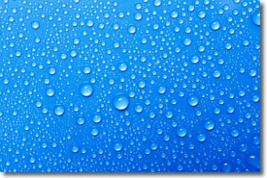
Condensation is the change of matter from a state of gas into a state of liquid,
and it happens because water molecules release heat into the atmosphere and
become organized into a more closely packed structure, what we might see as
water droplets.
Water is always present in the air around us as a vapor, but it's too small for
us to see. When water undergoes the process of condensation it becomes organized
into visible water droplets. You've probably seen condensation happen before on the
surface of a cold drink!
Next Topic: Contrails
Weather Topic: What are Cumulonimbus Clouds?
Home - Education - Cloud Types - Cumulonimbus Clouds
 Next Topic: Cumulus Clouds
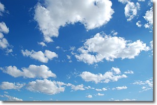
The final form taken by a growing cumulus cloud is the
cumulonimbus cloud, which is very tall and dense.
The tower of a cumulonimbus cloud can soar 23 km into the atmosphere, although
most commonly they stop growing at an altitude of 6 km.
Even small cumulonimbus clouds appear very large in comparison to other cloud types.
They can signal the approach of stormy weather, such as thunderstorms or blizzards.
Next Topic: Cumulus Clouds
Current conditions powered by WeatherAPI.com


