Weather Alert in Kentucky
Special Weather Statement issued September 5 at 9:33PM EDT by NWS Jackson KY
AREAS AFFECTED: Morgan; Johnson; Magoffin; Floyd
DESCRIPTION: At 933 PM EDT, Doppler radar was tracking a strong thunderstorm over Gifford, or over Salyersville, moving northeast at 35 mph. HAZARD...Wind gusts up to 50 mph and penny size hail. SOURCE...Radar indicated. IMPACT...Gusty winds could knock down tree limbs and blow around unsecured objects. Minor damage to outdoor objects is possible. Locations impacted include... Paintsville, Prestonsburg, Salyersville, Mason, Oaklawn Estates, Falcon, Wonnie, Burning Fork, Kernie, Collista, West Van Lear, West Royalton Station, Williamsport, Redbush, Swamp Branch, Ever, Auxier, Perlie, Niles, and Orient. THIS INCLUDES THE FOLLOWING HIGHWAYS... Bert T. Combs Mountain Parkway between mile markers 64 and 76. Kentucky Highway 3 in Floyd County between mile markers 3 and 4. Kentucky Highway 3 in Johnson County U.S. Highway 23 in Floyd County near mile marker 21. U.S. Highway 23 in Johnson County between mile markers 0 and 16.
INSTRUCTION: If outdoors, consider seeking shelter inside a building. Torrential rainfall is also occurring with this storm and may lead to localized flooding. Do not drive your vehicle through flooded roadways. A Severe Thunderstorm Watch remains in effect until 100 AM EDT for southeastern and northeastern Kentucky.
Want more detail? Get the Complete 7 Day and Night Detailed Forecast!
Current U.S. National Radar--Current
The Current National Weather Radar is shown below with a UTC Time (subtract 5 hours from UTC to get Eastern Time).

National Weather Forecast--Current
The Current National Weather Forecast and National Weather Map are shown below.

National Weather Forecast for Tomorrow
Tomorrow National Weather Forecast and Tomorrow National Weather Map are show below.

North America Water Vapor (Moisture)
This map shows recent moisture content over North America. Bright and colored areas show high moisture (ie, clouds); brown indicates very little moisture present; black indicates no moisture.

Weather Topic: What is Hail?
Home - Education - Precipitation - Hail
 Next Topic: Hole Punch Clouds
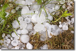
Hail is a form of precipitation which is recognized by large solid balls or
clumps of ice. Hail is created by thunderstorm clouds with strong updrafts of wind.
As the hailstones remain in the updraft, ice is deposited onto them until their
weight becomes heavy enough for them to fall to the earth's surface.
Hail storms can cause significant damage to crops, aircrafts, and man-made structures,
despite the fact that the duration is usually less than ten minutes.
Next Topic: Hole Punch Clouds
Weather Topic: What are Mammatus Clouds?
Home - Education - Cloud Types - Mammatus Clouds
 Next Topic: Nimbostratus Clouds
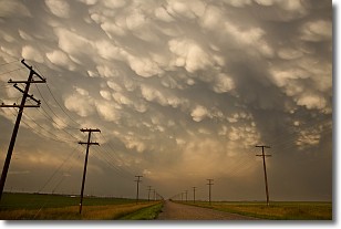
A mammatus cloud is a cloud with a unique feature which resembles
a web of pouches hanging along the base of the cloud.
In the United States, mammatus clouds tend to form in the warmer months, commonly
in the Midwest and eastern regions.
While they usually form at the bottom of a cumulonimbis cloud, they can also form
under altostratus, altocumulus, stratocumulus, and cirrus clouds. Mammatus clouds
warn that severe weather is close.
Next Topic: Nimbostratus Clouds
Current conditions powered by WeatherAPI.com


